|
AutoMapa Poland XL is the most comprehensive, accurate and popular navigation map of Poland on the market.
It features all the information required for effective road navigation.
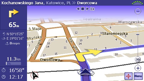
The heart of the product is a comprehensive vector map of roads to all residential locations in Poland. The map covers all road categories from freeways, expressways, international and domestic roads to local and even dirt and forest roads.
The first map version, published in 2003, was developed based on a military topographic map in 1:50 000 scale provided by the Military Geography Board of the Polish Army General Headquarters.
Topographic map data was gradually verified with the use of satellite images and field measurements to produce the most accurate and comprehensive road map of Poland.
The navigation maps of all Polish towns have been developed with utmost precision. Generated based on aerial photos and satellite images, they deliver a precision level which corresponds to 1:5 000 for paper maps, i.e. around 1m in the field.
In addition to a detailed road grid, navigation maps also contain detailed descriptive information on: road categories and traffic direction, multi-lane roads, roundabouts, squares, residential districts, green areas (parks), rivers, water courses and industrial areas.
Precise contours of buildings and their accurate address points are an absolutely unique feature of the AutoMapa system on the international scale. Other maps use approximate address data calculated based on property numbers at road junctions. Such information may be sufficient in small towns but it fails to deliver an adequate level of accuracy in large cities. This is why the precise address points in AutoMapa have earned widespread recognition among taxi drivers.
Points Of Interest (POI) are a very important feature of the system. AutoMapa comprises an extensive POI data base. The basic categories are: Embassies, Pharmacies, Banks, ATMs, Swimming Pools, Cemeteries, Railway Stations, Night Clubs, Galleries, Hotels, Cafes, Cinemas, Police Stations, Churches, Bowling Alleys, Florist Shops, Airports, Playgrounds, Museums, Post Offices, Emergency Rooms, Pubs, Restaurants, Petrol Stations, Stadiums, City Guard, Fire Department, Hospitals, Theatres, Institutions, Schools, Public Utility Sites (shopping centres, etc.).
|


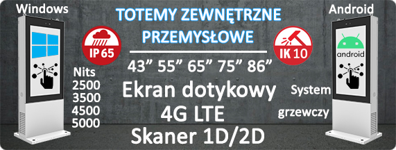
 Industrial Outdoor Totems

.png)
.png)
.png)


 PL
PL eng
eng